Search
Project description This project support the development of 10-year global forecasts of nets, insecticides, diagnostics, and treatments for malaria
The Mental Health Commission (MHC) of Western Australia has provided funding to The Kids Research Institute Australia to undertake exploratory research to inform a WA approach to aftercare.

Honorary Team Member
WA’s current Omicron COVID-19 outbreak could jump by 147,000 cases if mask mandates are abandoned before the Easter long weekend, according to sophisticated new modelling.
A regional corner of Africa is a hotspot for cases of HIV, tuberculosis and malaria, prompting researchers to call for targeted health support rather than a national response.
The Malaria Atlas Project (MAP) aims to disseminate free, accurate and up-to-date geographical information on malaria and associated topics. Our mission is to generate new and innovative methods to map malaria, to produce a comprehensive range of maps and estimates that will support effective planning of malaria
Adam Dan Francesca Susan Saddler Weiss Sanna Rumisha PhD PhD Dr PhD (Biostatistics) Senior Research Officer Honorary Research Fellow Research
Nick Golding BSc DPhil Honorary Research Fellow Nick.Golding@thekids.org.au Honorary Research Fellow Professor Nick Golding is the UWA Chair in

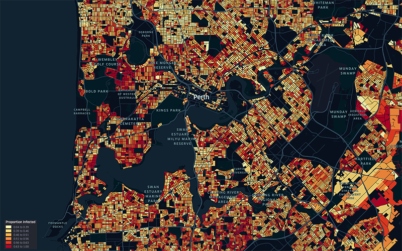
Our Child Health Analytics Team uses cutting-edge technologies to better understand how and why the health and wellbeing of children varies from place to place. We develop innovative geospatial methods that can harness large, complex datasets to pinpoint hotspots of elevated risk, evaluate change through time, and explore underlying drivers.
Climatic conditions are a key determinant of malaria transmission intensity, through their impacts on both the parasite and its mosquito vectors. Mathematical models relating climatic conditions to malaria transmission can be used to develop spatial maps of climatic suitability for malaria. These maps underpin efforts to quantify the distribution and burden of malaria in humans, enabling improved monitoring and control.