Search
Strongyloidiasis, caused by the soil-transmitted helminth Strongyloides stercoralis, remains a neglected public health issue in Australia, particularly among remote Aboriginal and Torres Strait Islander communities. This study aimed to map the spatial distribution of strongyloidiasis and investigate associated socioecological factors to identify high-risk areas and guide targeted interventions in Australia.
Bacillus Calmette-Guérin (BCG) protects children from severe tuberculosis and remains the only licensed vaccine for tuberculosis. Subnational estimates of BCG coverage are essential for identifying underserved populations across Africa. This study aimed to map BCG vaccination coverage in Africa from 1990 to 2022.
Fertility rates are key indicators of population health and demographic change, influencing economic development, healthcare planning, and social policies. Understanding subnational variation in fertility rate is important for effective geographical targeting and policy prioritization. This study aimed to identify geographic variation, trends, and determinants of fertility rates in Ethiopia over the past two decades.
Climatic conditions are a key determinant of malaria transmission intensity, through their impacts on both the parasite and its mosquito vectors. Mathematical models relating climatic conditions to malaria transmission can be used to develop spatial maps of climatic suitability for malaria. These maps underpin efforts to quantify the distribution and burden of malaria in humans, enabling improved monitoring and control.
Malaria is a focal disease and more localized in low endemic areas. The disease is increasingly becoming a concern in urban areas in most sub-Saharan African countries. The growing threats of Anopheles stephensi and insecticide resistance magnify this concern and hamper elimination efforts. It is, therefore, imperative to identify areas, within urban settings, of high-risk of malaria to help better target interventions.
Malaria incidence (MI) has significantly declined in Nepal, and this study aimed to investigate the spatiotemporal distribution and drivers of MI at the ward level. Data for malaria cases were obtained from the National Surveillance System from 2013 to 2021. Data for covariates, including annual mean temperature, annual mean precipitation, and distance to the nearest city, were obtained from publicly available sources. A Bayesian spatial model was used to identify factors associated with the spatial distribution of MI.
Arboviruses transmitted mainly by Aedes (Stegomyia) aegypti and Ae. albopictus, including dengue, chikungunya, and Zika viruses, and yellow fever virus in urban settings, pose an escalating global threat. Existing risk maps, often hampered by surveillance biases, may underestimate or misrepresent the true distribution of these diseases and do not incorporate epidemiological similarities despite shared vector species.
With more than 1.2 million illnesses and 29,000 deaths in sub-Saharan Africa in 2017, typhoid fever continues to be a major public health problem. Effective control of the disease would benefit from an understanding of the subnational geospatial distribution of the disease incidence.
Post-tuberculosis (TB) sequelae present a significant challenge in the management of TB survivors, often leading to persistent health issues even after successful treatment. Identifying risk factors associated with post-TB sequelae is important for improving outcomes and quality of life of TB survivors. This systematic review and meta-analysis aims to identify risk factors associated with long-term physical sequelae among TB survivors.
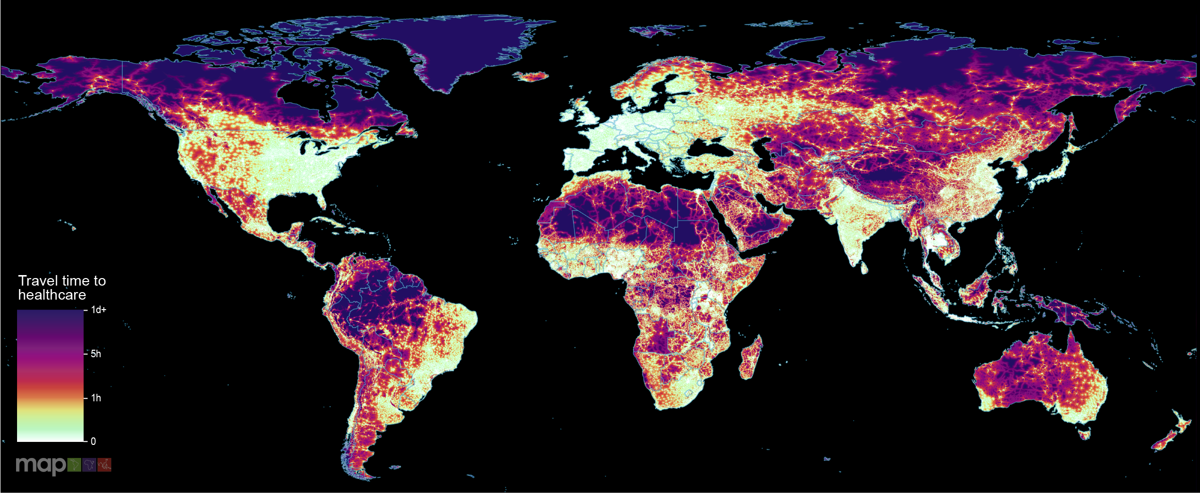
New research which maps the entire global population’s travel time to their nearest healthcare facility has revealed major inequalities in access to healthcare depending on whether people have access to motorised transport or not.